ATOC 1060 Overheads (and then some)
 El
Nino Lectures March 29 and April 2
El
Nino Lectures March 29 and April 2
Figure 1 - What is El Nino?
Figure 2 - Wind direction and magnitude
and water temperature at 110 W, equator
Figure 3 - Monthly average sea-surface
temperatures at the equator, 1986-1998 (from NOAA)
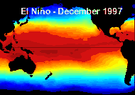
Figure 4 - Maps of sea-surface temperatures
for El Nino, La Nina, and normal conditions
Figure 5 - Global map of regional climatic
impacts of El Nino
Figure 6 - Impact of El Nino on precipitation
(in mm....note divide by 25 for inches, not 4!!)
Figure 7 - Extreme weather events due
to 1998 El Nino in the United States
Figure 8 - Global map of impact of 1982-1983
El Nino event on precipitation
Figure 9 - El Nino distorts the normal
pressure surfaces in the north-east Pacific Ocean (compare to
normal)
 Paleoclimate
Lectures - April 5 and April 7
Paleoclimate
Lectures - April 5 and April 7
Figure 1 - Record of past El Nino events
based on isotopes of oxygen
Figure 2 - Paleo record of temperature
in the northern hemisphere from 1400 AD to present
Figure 3 - Correlation of northern hemisphere
temperatures from Figure 2 with solar and atmospheric CO2 variations
Figure 4 - Inferred global average northern
hemisphere average temperatures based on "bore holes" (red) compared to
air temperature measurements
Figure 5 - Average precipitation (in
mm of water) over Antarctica
Figure 6 - Ice core record of global
temperature (based on isotopes) going back over 2000 years!
Figure 7 - Distribution of forests in
the eastern US and Canada since the last ice age, based on pollen records
Figure 8 - Cross section of a tree used
for determining climate based on the width of tree rings
Figure 9 - Cross section of layering
in coral used for determining changes in sea surface temperatures
Figure 10 - Reconstruction of sea surface
temperatures from the last ice age, based on paleoclimate data
 Ice
Ages and Milankovitch Cycles - April 9
Ice
Ages and Milankovitch Cycles - April 9
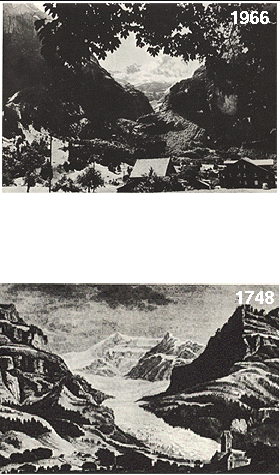
Figure 1 - Painting of a Dutch river
frozen over during the period of the "little ice age"
Figure 2 - Historical record of earth's
average temperature deduced from "proxy" records
Figure 3 - Tilt of the earth's axis and
eccentricity of orbit play key roles in controlling the distribution of
sunlight on earth
Figure 4 - Schematic of the precession
of the equinoxes that affects the seasonality of sunlight falling on the
earth
Figure 5 - Chart of distribution of plant
habitats (biomes) on earth, present day
Figure 6 - Chart of distribution of biones
on earth during last ice age
Figure 7 - Present day forests and deserts
on earth
Figure 8 - Forests and deserts on earth
5000 years ago
Figure 9 - Forests and deserts on earth
during last ice age
Figure 10 - Distribution of land types
during last ice age 15,000 years before present
Figure 11 - Western US map of land types
during last ice age
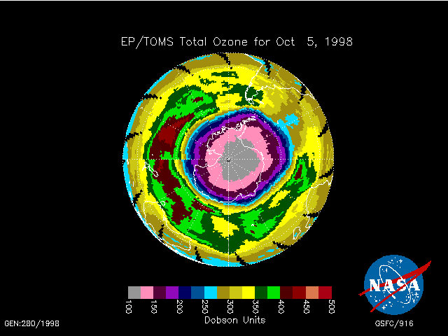 Ozone
depletion - April 14, 16
Ozone
depletion - April 14, 16
Figure 1 - A schematic of the processes
that transport chlorine to the stratosphere
Figure 2 - Pie chart showing the contributions
of different chlorine compounds to the stratosphere
Figure 3 - Altitude profiles of CFC-11
and CF4 showing that CFC-11 breaks down in the stratosphere
Figure 4 - What's wrong with this "commentary"?
Figure 5 - The "differences" between
ozone in the troposphere and in the stratosphere
Figure 6 - It takes these chemical reactions
and more to calculate ozone abundances in the stratosphere
Figure 7 - Ozone absorbs in the UV where
there isn't much sunlight, but what little is there is lethal
Figure 8 - Diagram showing why UV radiation
at 300-315 nm (UVb) is harmful
Figure 9 - Things aren't always what they
seem
 Climate
Change - The Human Dimension, April 19, 21, 23
Climate
Change - The Human Dimension, April 19, 21, 23
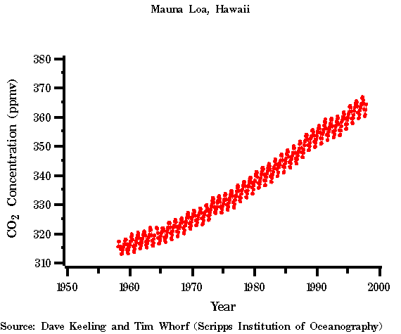
Figure 1 - Measurements of Carbon Dioxide
from Mauna Loa and South Pole, 1957-1990
Figure 2 - The expected change in radiative
forcing ("heating") of the earth's surface by various processes
Figure 3 - Map of biological productivity
in the world's oceans
Figure 4 - Reconstructed abundances of
atmospheric CO2 for the past ~1000 years from ice cores
Figure 5 - Reconstructed CO2, temperature
change, and methane for the past ~220,000 years, for ice cores