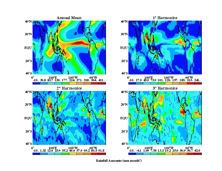
The seasonal cycle over the western equatorial Pacific is relatively feeble. For example, it can be seen from decomposing monthly mean precip estimates from the Microwave Sounding Unit (MSU) that the western equatorial Pacific (WEP) is a local minima in all harmonics of the annual cycle, while the mean precipitation is relatively large however. This contrasts other regions of the tropics and subtropics where the first harmonic of the annual cycle is relatively large. The magnitude of precipitation by seasonal average also demonstrates the intensity of precipitation over the Warm Pool. It is a dominant feature in mean tropical precipitation throughout the year.
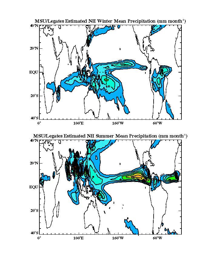
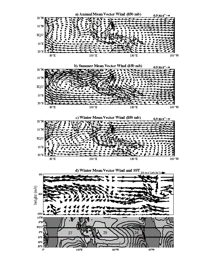
Mean winds are slight easterly in the boreal summer and slight westerly in boreal winter. As winds over the warm pool reverse seasonally they are considered to be monsoonal (Ramage,). Precipitation over the area is intense in every season and skies in the region are continually cloudy.
Seasonal mean moisture transports by the large-scale circulation are marked by considerable trade wind advection of moisture across the central pacific, north west to the Philippines. As mean winds over the Aratura Sea and Coral Sea are weak, little moisture is transported into the south equatorial Warm Pool.
A zonal profile of the climatological mean winds reveals a
structure commonly referred to as the
Walker Cell. Above the
warm SSTs of the WEP, ascent and deep convection dominates. Westerly winds
prevail over the Indian Ocean and easterlies
cover the Pacific. Both help to advect moisture towards convection over
the Warm Pool.
Balancing ascent over the Warm Pool, the decending branches of the
Walker Cell are located over
the coolest tropical surface temperatures -- the Arabian Sea and Eastern
Pacific. This zonal structure it will be argued
can help explain the observed phasing of convection and dynamics during
Westerly Wind Bursts.
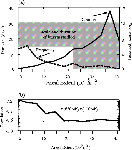
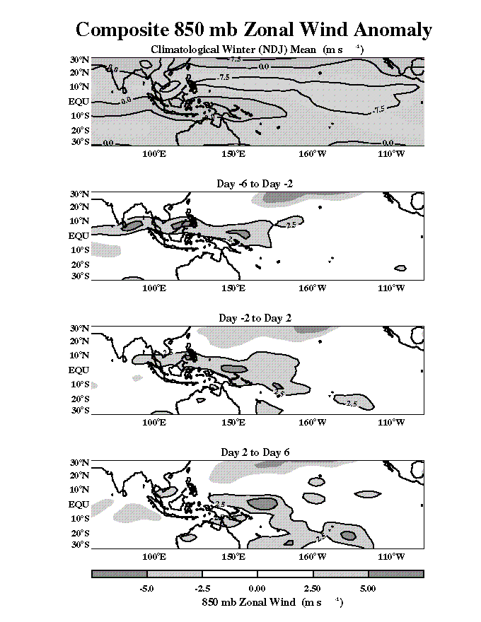
The vertical structure of surface westerly wind anomalies and the dependence
of that vertical structure on horizontal
850mb spatial extent is investigated here. Anomalies during all seasons are
considered.
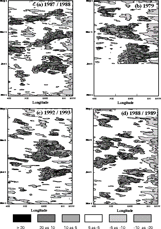
A hovmoller diagram of events identified by this technique shows an
eastward propagation of 5 m/s westerly
winds. This pattern is analogous in form and phase speed to much previous
work which has been done on the Intraseasonal
Oscillation (Madden and Jullian, 1972).
Events are identified by 5 m/s 850mb anomalies (mean and 1st 3 harmonics
of annual cycle removed) within the region
of the WEP surrounded by (130E-150E, Eq-10S). Maximum spatial extent of
westerly anomalies within this region defines
a time origin (Day 0) and correlations between those model grid
points where 850mb U > 5m/s and the zonal winds
throughout the vertical are calculated.
This plot shows that smaller scale events have an
nearly barotropic structure whereas larger scale events
are dominated by the first baroclinic mode
(bottom caption). The top caption shows the relationship
between size and duration of these events. Smaller events are
more numerous but last considerably shorter than their
larger counterparts.
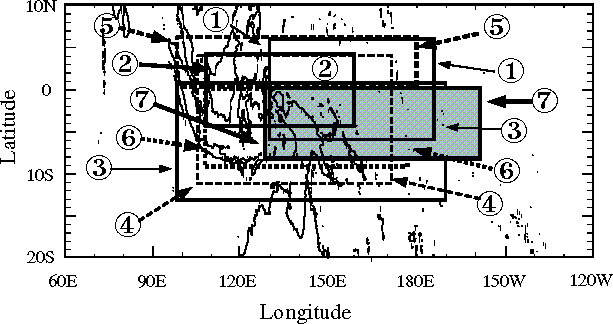
Seven westerly wind bursts are identified during the Northern
winter months of November to January, 1985-1993. These seven
events are chosen because they are periods of sustained 5m/s
westerly 850mb winds over the Warm Pool, of significant spatial
extent. A temporal origin, Day 0, is selected as the time at
which 5m/s westerly 850mb winds reach maximum horizontal spatial
extent.
Burst regions are the longitude/latitude boxes which surround
5m/s westerly 850mb winds at Day 0.
Thus, a different burst region is chosen for each event. Over
each of these regions various paramters will be
averaged to show single dimensional temporal trends in the
atmosphere, ocean and surface energy balance.
These 7 events occur during Nov/Dec 1986, Nov 1987, Dec 1987,
Nov 1989, Nov 1990, Dec 1990 and Dec 1992. Their locations
are shown by this map.
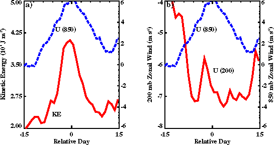
850mb westerly winds are the identifing feature of the events
studied here.
Zonal winds at upper and lower levels are highly
anticorrelated, giving the impression of a highly baroclinic
flow--one in which density and pressure surface do not coincide.
This
allows for a vertical shear in zonal wind as the horizontal
pressure gradient can change with height.
As upper level winds are anticorrelated with low level
winds, the total momentum of the atmospheric column is not
as strongly westerly
as one would expect from analysis of the low level flow alone.
The kinetic energy of the column increases as the absolute magnitude
of winds throughout the vertical generally increases.
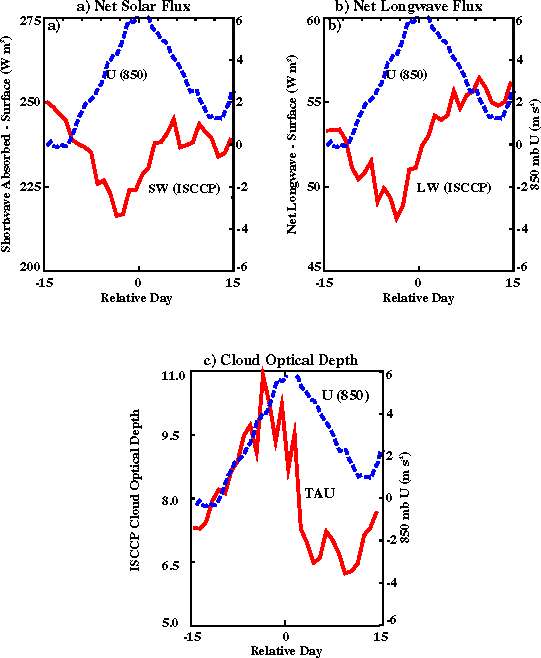
Composites of Cloud Optical
Depth as derived by ISCCP
show periods of substantially increased convection prior
to the peak in surface westerly winds. The typical distribution of convection
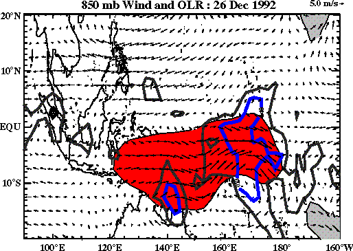
during the WWB studied here can be seen in a
snapshot of OLR and winds taken during December 1992. This
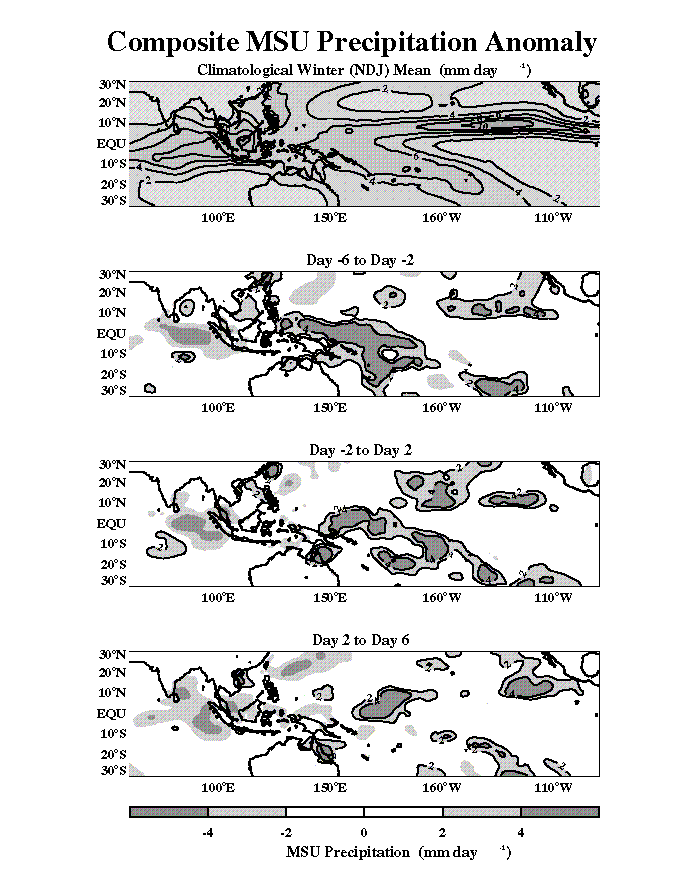
phasing of deep convection is further supported by
measurements of precipitation taken from MSU
winds and
rain in a composite of all events. A possible physical interpretation of the phasing of
winds and convection is that with the eastward migration of deep convection, the
dynamics of the climatological mean Walker Circulation
are also displaced eastward, causing westerly winds to extend across
the Warm Pool and easterlies aloft. As the events are
therefore a coupled dynamic/convective phenomenon, regional thermodynamics
must be analized to gain an understanding of the physical
mechanisms at work during their lifecycle.
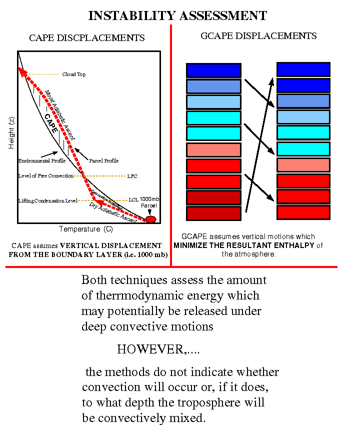
One important thermodynamic quantity is Convective Available
Potential Energy (CAPE) which attempts
to measure the latent stability of the atmosphere. To estimate
this quantity, temperature and humidity from
the NCEP/NCAR Reanalyses are used. Parcels from 1000mb are
lifted dry adiabatically until they saturate. From
there, they are lifted moist adiabatically to the point where
they freely convect (are lighter than the environment).
The force exterted by their bouyancy integrated vertically
through the atmosphere gives a measure of the amount
of convective instability provided by the mean environment.
(Cape Schematic Figure).
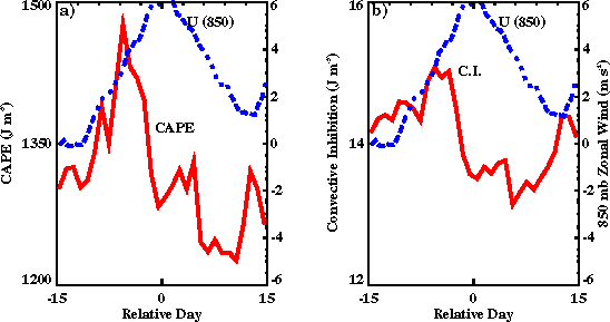
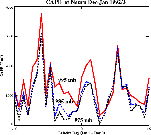
Analysis of CAPE over burst
periods shows a precipitous drop in values
during the periods of deep convection at the burst onsets.
This drop can also be seen in
soundings from Nairu during the
December 1992 burst.One possible explanation of this drop is
as a conversion of stored thermodynamic atmospheric energy to
kinetic energy on a very large scale. The change of CAPE --
a quantity dependent on atmospheric vertical structure --
correlates strongest to atmospheric variability at lower levels,
especialy those at 1000mb. Small changes at this level have
considerable impact on CAPE as they determine the moist
static energy of the atmosphere's most energetic layer.
Cooling at 1000mb is largely
responsible for the signal observed in CAPE. Variability at
other levels does exist but shows substantially smaller
correlation to trends in CAPE than at 1000mb.
CAPE analyses is traditionally applied to single soundings
and not to GCM grid scale data. Thus the calculations here
are more reflective of changes in the mean environment than in
single convective cells. If one assumes that convection
occurs over 10km horizontal scales and that small scale processes
contribute to a normal distribution of temperature
fluctuations within each 2.5 degree grid, than the importance of
the observed changes in temperature and humidity are
compounded due to the nonlinearity of the relationship between
CAPE and 1000mb temp. The deep convective anomalies seen earlier
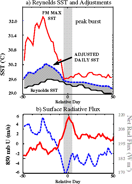
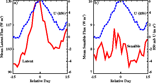
are cause significant changes in surface radiative fluxes.
Similarly, changing winds cause heightened surface turbulent
fluxes, especially the latent flux of moisture. Together these
energetic perturbations are responsible for an
observed decrease in SST (annual
cycle has been removed).
Magnitudes of
these perturbations are of the same order of magnitude,
although their phasing is somewhat different as radiative
flux perturbations
are in phase with thick clouds while turbulent flux
perturbations are in phase with high surface winds. These
surface winds typically
follow the convection by the order of a few days. In addition,
heightened radiative fluxes generally preceed increased
cloudiness,
making their integrated effect less important as the temporal
window of analysis is increased. More quantitative estimates of these
perturbations are pending.
Composite time series of radiative fluxes
and turbulent fluxes evidence this fact.
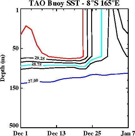
The oceanic response to these events is considerable as
both the thermodynamic and dynamic surface forcings deviate
substantially from the climatological mean.
Thermal changes in the oceanic vertical structure are
clearly descernable in TAO buoy measurements .
Similarly, accelerated eastward currents are observed -- resulting from
eastward surface stress due to the winds. Other studies
have shown a westward acceleration of the Equatorial Undercurrent.
Composite Reynolds SST is shown here.
The oceanic response to WWB is complicated by a fine
upper ocean structure response. As it is the top few millimeters of
the ocean which communicate fluxes of energy, the
temperature of that layer is critical for determining ocean/atmosphere
interaction. That temperature however experiences considerable
diurnal variation as changes in solar radiation, wind driven
mixing, and stabilizing fresh water flux influence the
stratifcation of the "skin" layer.
A parameterization developed by Webster et al. (1995)
is used here to estimate the thermal variability of the skin layer.
It is found that the diurnal cycle in SST decreases considerably
during the westerly winds.
WWB represent periods of considerable atmospheric and oceanic
variability over the tropical western Pacific Ocean.
WWB probably result from a dynamic/thermodynamic coupling and their
structure can at least in part be understood by interaction of the
climatological mean Walker Circulation and eastward propagating
convection. Atmospheric latent stability is highly influenced by
low-level fluctuations in moisture and temperature. This relationship
is highly non-linear. Thus processes which influence the
moist static energy of the boundary layer (including oceanic processes)
can have important ramifications for the large-scale
atmospheric circulation.
WWB have striking impact on the surface energy balance and the heat content
of the oceanic mixed layer. The physical mechanisms responsible
for this deficit are evaporation and reduced surface solar radiation.
Esimates show the relative magnitudes of these deficits are of the
same order of magnitude however, when integrated over time, anomalous
evaporative fluxes outweigh radiative deficits by about a factor
of two.
BACK TO TOP
Statistics of Intraseasonal Variability over the Warm Pool
BACK TO TOP
Westerly Wind Bursts: The Composite Technique
BACK TO TOP
Composite Analysis :
WWB Part I: Dynamics
BACK TO TOP
Composite Analysis :
WWB Part II: Convection
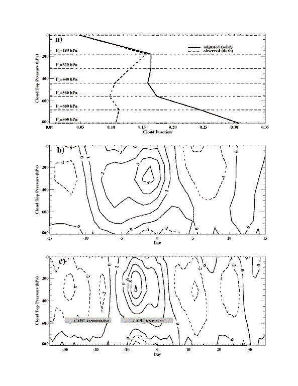
The evolution by cloud type diagnosed by ISCCP provides the opportunity to assess
fluctuations in cloud type more generally (than OLR for example). The evolution
of clouds type categorized by cloud top pressure over the IFA through large scale westerly
wind bursts is shown
here . (Cloud percent has been corrected for random cloud overlap).
BACK TO TOP
WWB Part III: Surface Energy Balance
BACK TO TOP
WWB Part IV: Ocean Response
BACK TO TOP
Conclusions
BACK TO TOP
----- Your are visitor #